

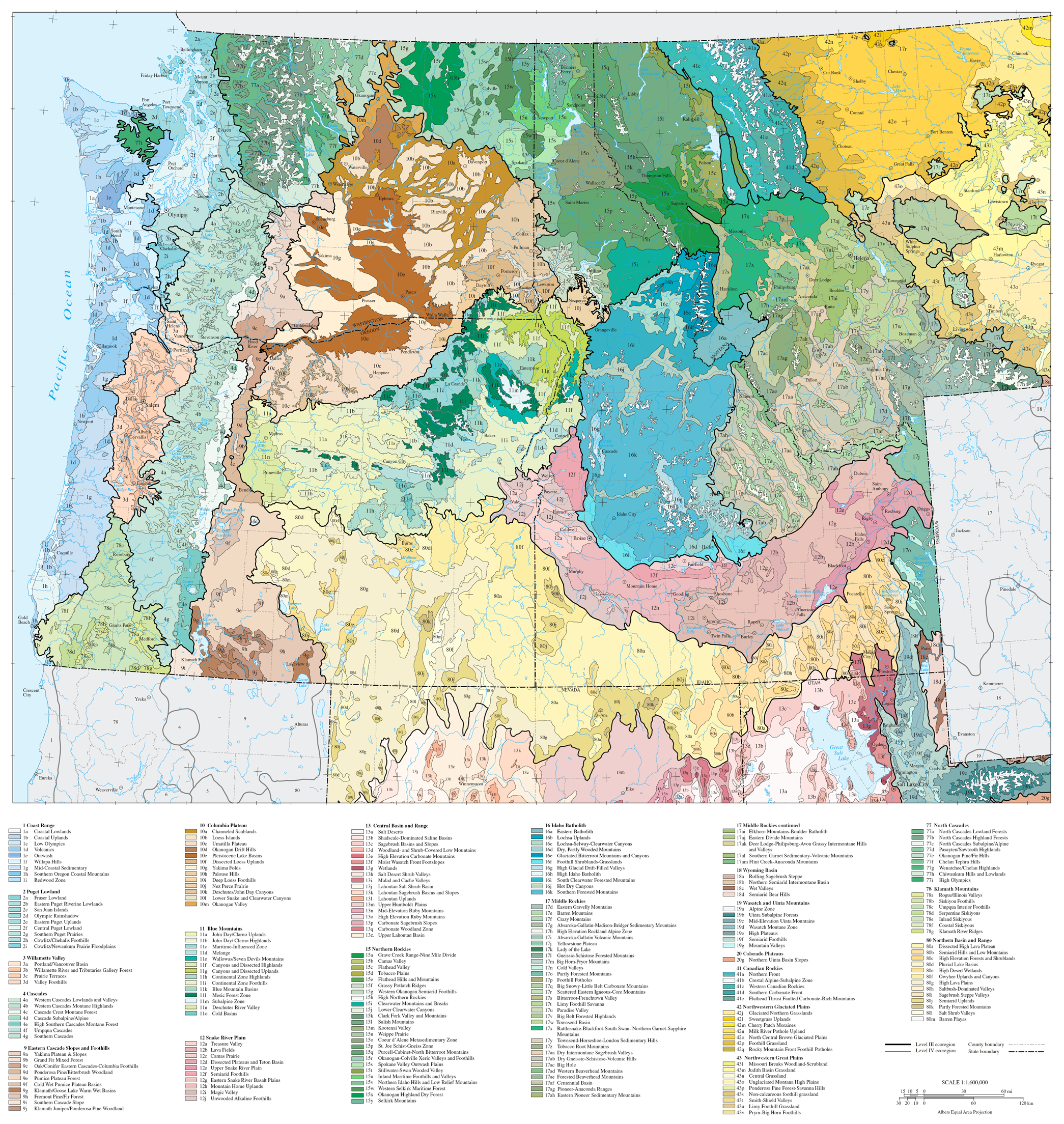
Below is a very nice United States based Cascadia Ecoregions Map as defined by the US Environmental Protection Agency. Ecoregions are areas where ecosystems (and the type, quality, and quantity of environmental resources) are generally similar, while Bioregions are one step above, and help denote the entire watersheds, from where the rain falls, to where it meets the ocean. These Bioregions often have interconnected geology, ecosystems, flora, fauna, hydrology, and from the shared connections and concerns of the people living there – a distinct culture, economy, and place.
In Cascadia – our bioregion is known as ‘Salmon Nation’ and extends from the copper river and Mt. St. Alias in the North, as far as the salmon swim, through the redwoods into Northern California and Cape Mendicino – and as far east as the Columbia, Fraser and Snake river extend…. all the way into Idaho and bits of Montana and Wyoming. Thinking about this as an entire interconnected system is critical for thinking about true sustainability, interdependence and independence, because any issues, whether it be food resiliency, pollution or disaster response – must take in the entire watershed. Together, we will always have more in common, than those thousands of miles away, and with little vested interests in our region, or shared cultural traits.
Cascadia Ecoregions Map

See the full Cascadia Ecoregions Map here or download the full size PDF here.
If you would like to learn more about the Cascadia Ecoregions Map, or how the EPA defines other ecoregions, here is the description from the US EPA on the purpose of ecoregions:
“Designed to serve as a spatial framework for the research, assessment, and monitoring of ecosystems and ecosystem components, ecoregions denote areas of similarity in the mosaic of biotic, abiotic, terrestrial, and aquatic ecosystem components with humans being considered as part of the biota. These regions are critical for structuring and implementing ecosystem management strategies across Federal agencies, state agencies, and nongovernmental organizations that are responsible for different types of resources within the same geographic areas. These phenomena include geology, landforms, soils, vegetation, climate, land use, wildlife, and hydrology. The relative importance of each characteristic varies from one ecological region to another regardless of the hierarchical level.”
Bioreigon and Ecoregion map of North America:

In the method that the EPA classifies them for this Cascadia Ecoregions Map , there are 12 level one ecoregions in the US, 25 level two, 105 level 3 ecoregions, 967 level four ecoregions.
You can read more about the Cascadia Bioregion here, or more Cascadia related news here.
